
Urban green spaces (UGS) are an important foundation to support sustainable urban development and benefit the well-being of residents. However, access to green spaces is a complex and dynamic process.
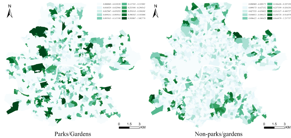
We used the latest Open Greenspace dataset released by Ordnance Survey (OS) in 2023 ( https://www.ordnancesurvey.co.uk/ ). OS is a provider of basic geographic information data support to public sector organizations in the UK. This data provides UGS data for Greater London and classifies multiple types of urban green space based on their function, including parks, gardens, allotments, community greenery, play spaces, sports facilities, cemeteries, religious grounds, and more. Many studies of UGS accessibility have focused primarily on parks or gardens, ignoring the multiple vegetation types of informal green spaces, namely non-parks. Therefore, this paper explores the impact of UGS type on accessibility by categorizing UGS into two types: Parks/Gardens, Non-Parks/Gardens.
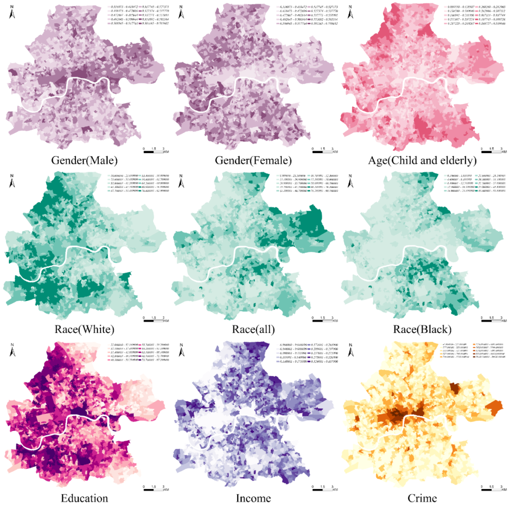
We collected LSOA-level socioeconomic data based on multiple data sources (Fig. 4). Population, gender, and age data were obtained from the London Datastore’s Census Information Scheme, released in 2021. The program is part of the Greater London Authority and provides census statistical information for the 33 London boroughs. The dataset summarizes the total population of the London boroughs based on gender and age, we used gender-based population data as well as extracted data on children (0-14) and the elderly (≥65) by age.
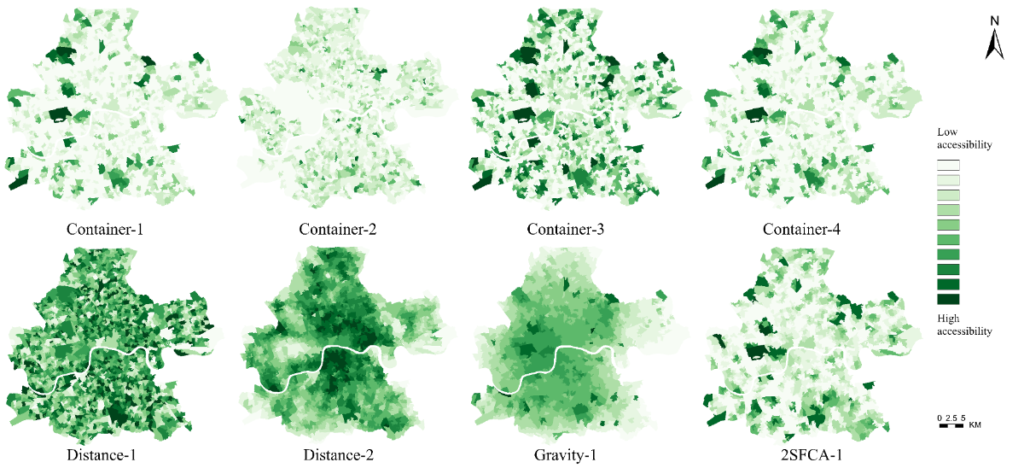
We calculated Inner London UGS accessibility by using four methods and the results are presented. The UGS accessibility is divided into ten grades, with greener colors representing greater accessibility. Most of the indicators showed significant variation in the results, but container-1, container-4, and 2SFCA results have some similarities.
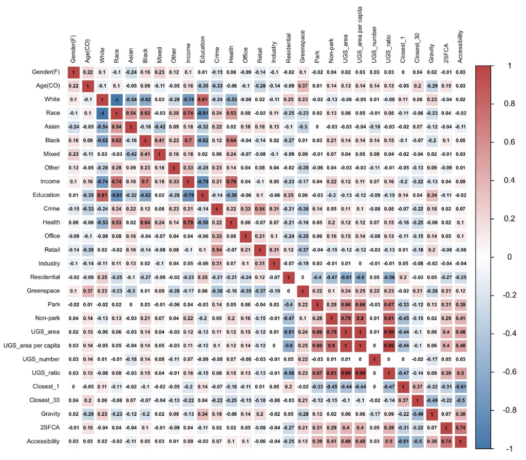
The heatmap visually represents the significant relationships between the variables. “Greenspace” presents a negative correlation with “Crime” (-0.38), “Office” (-0.35), and “Retail” (-0.37), which indicates that high UGS proportions are associated with lower crime rates and less green space in office and retail areas. “Residential” is negatively correlated with “Park” (-0.40), “Non-park” (-0.47), “UGS area” (-0.61), “UGS area per capita” (-0.60), “UGS ratio” (-0.56) are significantly negatively correlated, indicating that residential areas have inadequate green space, with less UGS per capita, which shows that the provision of UGS fails to meet the actual needs. The high correlation coefficients of “Non-park” with “UGS area”, “UGS area per capita”, and “UGS ratio” (0.79, 0.80, 0.81) indicate that diversified green space types contribute to improving the equity of green space accessibility.
Publication: Zhang, Kaiqi., Chen, Mingze*. Multi-method analysis of urban green space accessibility: Influences of land use, greenery types, and individual characteristics factors. Urban Forestry & Urban Greening | https://doi.org/10.1016/j.ufug.2024.128366 [ download ]